A Guide to the County of Yorkshire, Naturally

Yorkshire (God’s own county) is one of England’s largest, spanning west, north and east England. It’s home to two National Parks (plus parts of the Peak District), quite a few cities, seaside resorts and windy rainy weather!
When out walking, always follow the Countryside Code, to keep all creatures safe. At the coast, read how to keep dogs safe by the seaside.
The Yorkshire Dales is home to many stone-built villages and dramatic waterfalls, amid heather moorland that stretches into Lancashire and Cumbria. It’s home to 100 species of nesting birds, 30 species of mammals, 25 species of butterflies, 1000 species of moth and a unique moss not found elsewhere. Here also lives the brown long-eared bat (his ears much longer than his body!)
The North York Moors (heather and ancient trees)

The North York Moors are wild and open, stretching from Thirsk and Helmsley to the Yorkshire coast at Whitby. Some valleys are dense with pine forest, while late summer bring purple heather that rolls over high moorland. This historic natural haven is a haven for walkers.
If out walking, always follow the Countryside Code, to keep all creatures safe. If at the coast, read our post on keeping dogs safe by the seaside.
Covering 44,000 hectares, the North York Moors features on of England’s largest expanses of heather moorland, plus is home to many ground-nesting birds like golden plovers and merlins. It also has one of northern England’s largest concentrations of ancient trees.
Not just inland, this National Park stretches to the Jurassic cliffs of the Yorkshire coast, with ancient villages like Staithes and Robin Hood’s Bay (where you paddle your toes, at then of Wainwright’s Coast-to-Coast Walk, which begins in St Bees in Cumbria.
Hikers can follow the horseshoe-shaped Cleveland Way, which winds around the park for 109 miles. You can also take in plenty of star-gazing, as the Moors are a designated International Dark Sky Reserve.
The North York Moors are more wild and open, stretching from Thirsk and Helmsley to the Yorkshire coast at Whitby. Some valleys are dense with pine forest, while late summer bring purple heather that rolls over high moorland. This historic natural haven is a haven for walkers.
Here you’ll find wildlife galore: over 100 species of nesting birds, 30 species of mammals, 25 species of butterflies and 1000 species of moths. The Yorkshire Dales are also home to the brown long-eared bat (his ears much longer than his body!) and a species of moss that is uniquely only grown here.
England’s longest cave system is here, in a region shaped by glaciers and home to Malham Cove and Gordale Scar. You’ll see lots of dry stone walls (built to keep animals safe) along your walks, and spectacular waterfalls like Hardraw Force, Janet’s Foss, and Aysgarth Falls.
River Wharfe: Yorkshire’s Famous Waterway

The River Wharfe winds for 65 miles through the heart of Yorkshire. Read Walking the Wharfe, a fantastic book about the river’s path, by your friendly expert guide!
The river begins in the village of Buckden, then flows south-east through beautiful countryside, before joining the River Ouse near Cawood. It supports many otters, kingfishers and herons, always on the banks, looking for fish. Rare wildflowers and mosses thrive on this river’s limestone edges.
The word ‘Wharfe’ is likely from Old Norse or Saxon for ‘winding’ or ‘swift’.
The waters can be dangerous here. One young couple on honeymoon in 1998 went for a riverside walk, and their bodies were found soon after. It’s believed they got caught out through rising water, due to heavy rain. They were buried together at the church where they had married.
Stay Well Away from The Strid
The Strid is very dangerous gorge where the river is forced through a gap of 12 feet. With underwater caverns, it has 100% mortality rate, for anyone who falls in. The water can rise 5 feet in minutes, and never increases in temperature, even in summer. Some say this could be the world’s most dangerous stretch of water. So steer clear.
A local legend (depicted in William Wordsworth’s poem The Force of Prayer is that young William de Romilly was overcome by the urge to jump the Strid. His greyhound sensibly refused to jump, but William got caught around the lead, and drowned.
His mother Lady Alice (of Skipton Castle) gave land to Augustinian canons to build an abbey where they could pray for her son’s soul. That became Bolton Abbey. Is this true? No-one knows.
Keeping the River Wharfe Clean and Safe
One local couple have just embarked on a 81 mile walk, to raise the importance of clean rivers. They want to ensure rivers remain litter-free with better sewage treatment.
A recent BBC report found that residents living near the River Wharfe are upset and angry, as some tourists are leaving everything from toilet roll to dirty nappies dumped by the riverside. Others left barbecues on ‘scorched grass’ (which could cause wildfires).
One resident said ‘You want people to come to this area. I am very lucky to live here. But just take your stuff home with you’.
Discover The Characterful Cities of Yorkshire
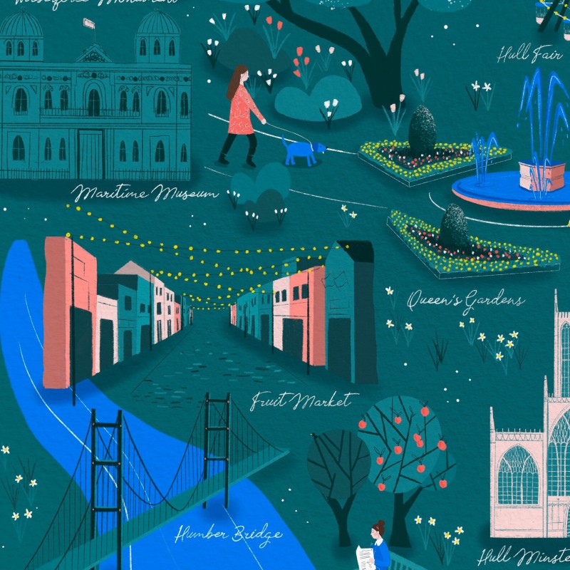
Hull, Hannah Penrose
Most of the 6 million or so people who live in Yorkshire, live in one of the following cities:
- Leeds is Yorkshire’s largest city and packed with independent boutiques and historic arcades like the Victoria Quarter. Roundhay Park is one of England’s best public parks.
- York is one of England’s most beautiful and historic cities, with cobbled streets, medieval halls and timber-framed houses. York Minister is a stunning Gothic cathedral, and the Shambles is a narrow winding street, lined with quirky shops and cafes.
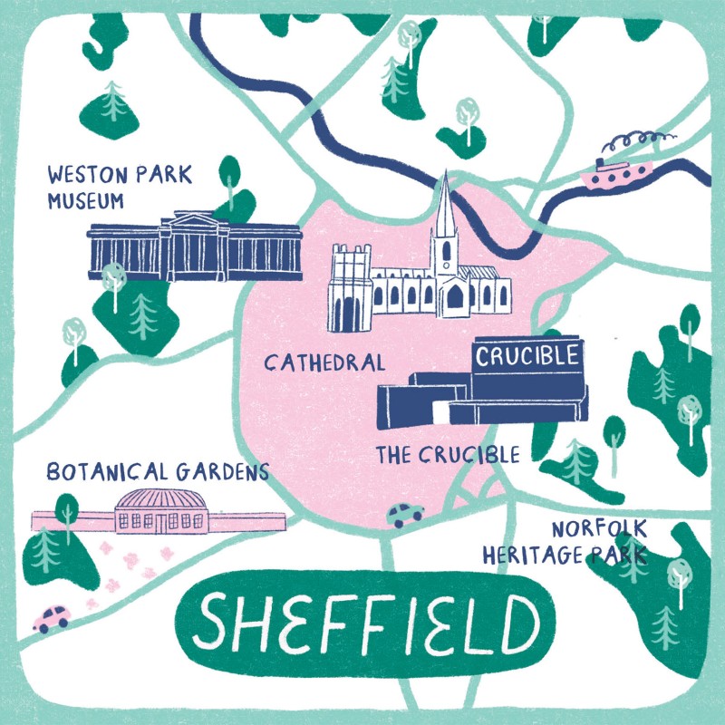
- Sheffield (South Yorkshire) used to be called ‘Steel City’ due to its industrial heritage, but is one of England’s greenest. Sitting near the Peak District National Park, the Winter Gardens brings nature to the city.
- Bradford is a city rich with culture (it’s the ‘curry capital of England!) along with grand Victorian buildings.
- Kingston Upon Hull sits on Yorkshire’s eastern edge, on the Humber Estuary. The Old Town is full of winding streets, historic pubs and winding squares, and unique museums tell the story of its maritime past, and links to poet Philip Larkin.
- Wakefield is a small city with a big arts scene (The Hepworth art gallery sits in a striking riverside building). The cathedral’s tall spire stands at the heart of a city that is a great base for exploring rural West Yorkshire, and the nearby Pennines.
- Doncaster is another South Yorkshire city, with roots that go back to Roman Times. Shaped by its train history, today it’s known for its lively market, old buildings and friendly community.
- Ripon is Yorkshire’s smallest city, with a cathedral that dates back to the 7th century. The compact city centre is filled with independent shops and tearooms. Each evening, the Hornblower sounds a horn in the market square.
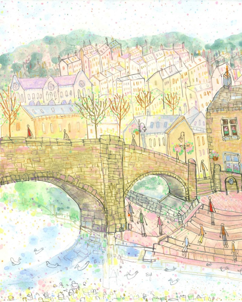
Hebden Bridge: A Unique Hill Town in West Yorkshire
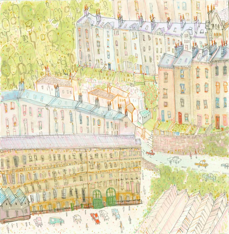
Hebden Bridge is one of the most unique towns in England, and also has the proud title of being home (along with Whitstable in Kent) to more independent shops than anywhere else in the country.

This very hilly town is situated in West Yorkshire. It has a strong history of mills that were used when the textile industry was strong. It was even called ‘trouser town’ as that’s where most people’s trousers were made, back in the day!
Today it features little eateries and independent shops, plus gorgeous riverside walks. It was also one of England’s first Transition Towns (that is, it is resilient to price shocks from oil on a national scale.
Instead, it has walkable communities, local farmers’ markets (that need no oil to transport food) and community solar panels, to bring free or affordable energy to local residents and businesses.
The area is also heavily associated with literature and art. Many writers and artists live here, or nearby. The town is strongly associated with former Poet Laureate Ted Hughes, who often featured the town in his work, and came from nearby.
His first wife (the late American poet Sylvia Plath) is buried in a small cemetery, not far from Hebden Bridge. And even if you’ve never been, you may recognise the scenery, as it was the setting for the popular BBC drama series Happy Valley.
Let’s Visit Yorkshire’s Historic Seaside Resorts

The east coast of Yorkshire is home to quite a few seaside resorts:
Robin Hood’s Bay is tucked between Whitby and Scarborough on Yorkshire’s wild coast, Robin Hood’s Bay (above) has cobbled streets that tumble down to a windswept harbour, where old cottages jostle for space, and the scent of sea air mixes with salt from rockpools.
It’s mostly known for being where you paddle your toes, to mark the end of Wainwright’s Coast-to-Coast Walk, which begins at St Bees village (on Cumbria’s west coast).
Scarborough was England’s first seaside holiday destination, due to the healing powers of the mineral waters that local resident Elizabeth Farrow discovered in 1626, when she stumbled upon a stream running from the cliffs.
Grand hotels like The Grand Hotel (opened in 1867) became landmarks, offering comfort and luxury to wealthy holidaymakers. Rows of guest houses and B&Bs followed. The opening of the railway station made the town accessible from York and Leeds.
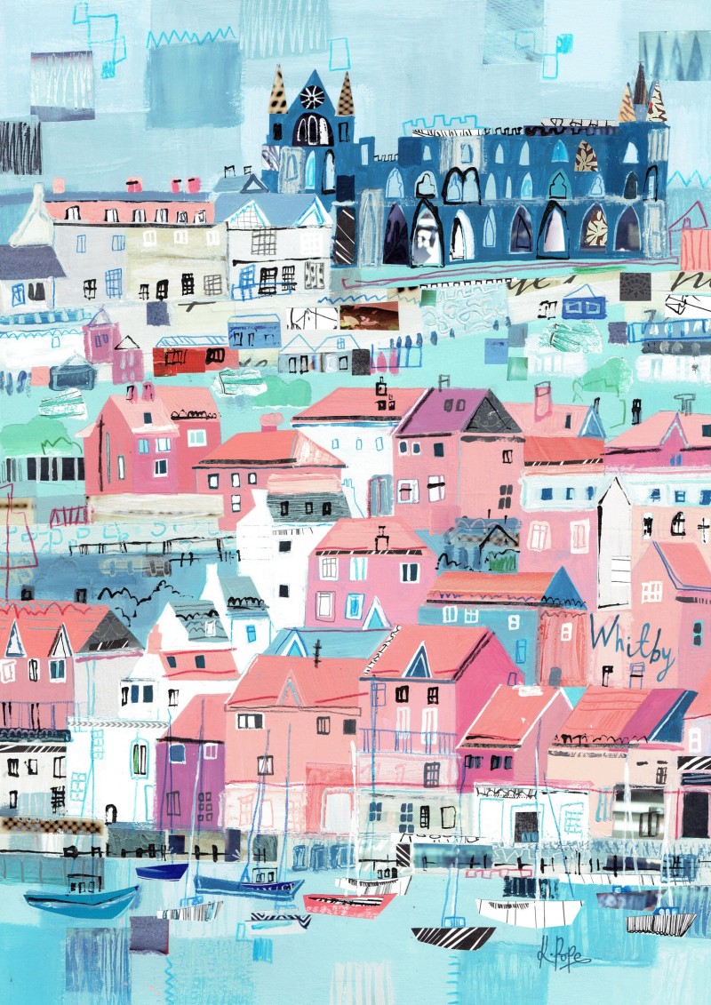
Whitby sits on the North Yorkshire coast, and is one of England’s most popular northern holiday destinations. With a sad history of whaling and links to Dracula, today it’s known for its sandy beaches on the Jurassic coast, and the 199 steps that lead up to St Mary’s Church and the abbey.
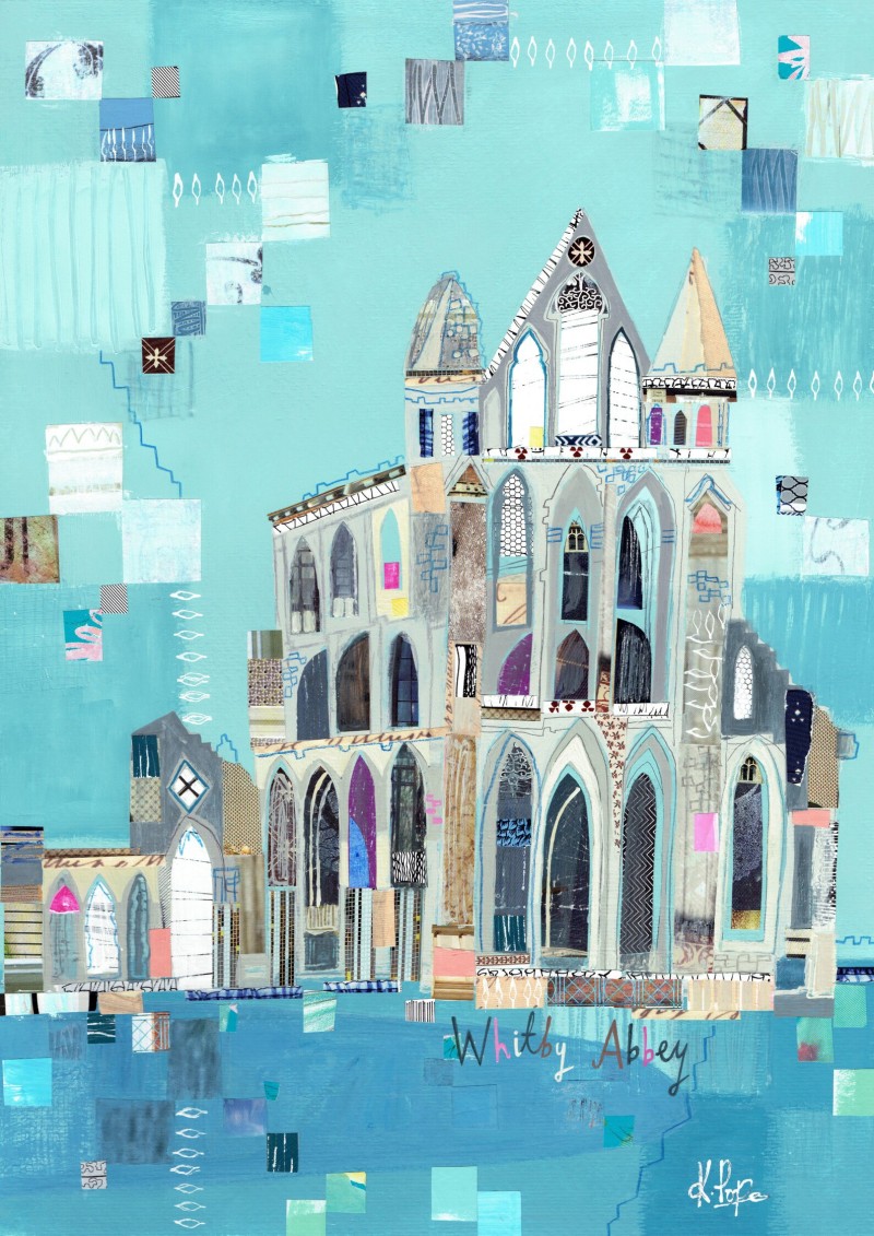
Perched on the East Cliff, the ruins of Whitby Abbey give unbeatable views over the town and coastline. Cross the swing bridge to the Old Town. Here, narrow cobbled lanes hide quirky shops, cosy pubs, antique sellers, and old bookshops.
Saltburn-by-the-Sea is home to England’s oldest cliff lift, a water-powered funicular railway built in 1884, to take people down to the pier. The town also features the only surviving pleasure pier in north east England, now a Grade II listed structure.
Bridlington is popular with wild swimmers. Home to one of England’s coastal weather stations, the 12th century priory was one of the country’s most wealthy, run by Augustinians.
It also hosted one of the first now not-very-politically-correct Miss Great Britain contests (began in Morecambe in 1945). Originally launched to boost tourism to seaside towns after World War II, in recent years some have boycotted them, others see them as harmless fun.
Winter Walks in Yorkshire (worth watching!)
BBC Winter Walks is one of the few modern programmes on TV that is worth a look. Beautifully done and relaxing to see, six well-known people take various walks through the Yorkshire countryside. Their commentary is accompanied by weather, routes and wind speeds. It’s beautifully made and educational too.
One of the walks features Morecambe Bay (always follow signs, to avoid dangerous tides and quicksand).
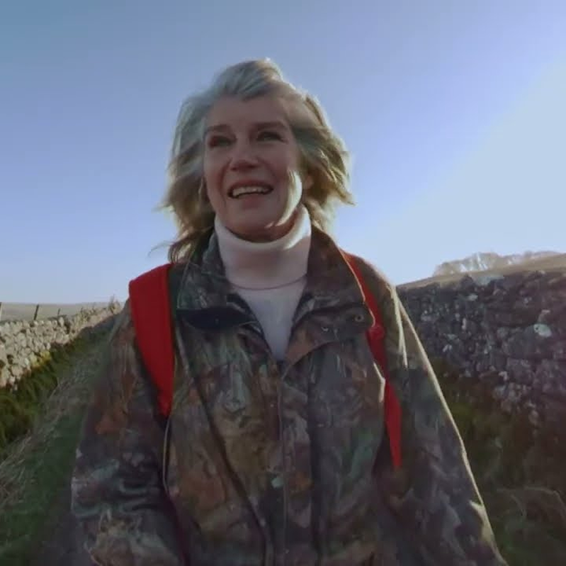
The presenters include Yorkshire Poet Laureate Simon Armitage, Rev Richard Coles and a lovely episode featuring former newsreader Selina Scott, who walks along the River Wharfe. She meets fellow walkers and old farmers along the way, finishing off with a pint at the local pub. It’s better than any meditation class!
She even recites poetry from Robert Frost and Shakespeare along the way!
Selina Scott (newsreader turned welfare campaigner)
Selina Scott is likely best known to most of us as the glamorous newsreader in the 80s and 90s. This programme is a revelation, with her gentle knowledge of nature and classic poetry. And a voice that should be on all relaxation and meditation tapes!
Born in Scarborough (England’s first seaside resort), she became News At Ten newsreader age just 29, and later presented one of the first breakfast TV shows. She has since said that her time on British TV was a ‘sex-obsessed nightmare’, claiming she was forced to kiss Jimmy Saville and refused to take part in the 40th anniversary celebrations, saying her complaints went ignored, due to the ‘masonic influence’.
At a time when others seemed to have no idea, Selina already had her suspicions, and had it written into her contract that no guests were allowed to kiss her, saying she found Saville repulsive. But to her bosses, he was ‘TV gold dust and untouchable’. Oh, if only they had listened to her?
She also interviewed Trump before he became President. And her questioning his honesty led to a program that he was so angry about, he began to publicly deride her, and bullied ITV into not showing the programme in the US.
Unsurprisingly, Selina ended up giving up the toxic world of TV news to run a farm, and now walks the hills, drink cups of black tea and present marvellous programmes like these. She was also instrumental in campaigning against the live export of animals (even turning into a Brexiter, so England could withdraw from European laws that allowed it).
She is still sceptical, concerned that the law that has now banned live export could still ‘shut the front door to leave the back door open, letting Northern Ireland and Ireland take the animals’.
Still strikingly beautiful in her 70s (she was friends with Princess Diana with whom she was constantly compared), today she campaigns for farmed animal welfare, tree-planting and native wildlife.
Selina says her proudest professional moment was exposing ivory poaching in Kenya with George Adamson (one of the couple featured in the film Born Free, weeks before he was killed by poachers). The programme led to an immediate ban on the ivory trade.
Yorkshire’s Simon Armitage (Poet Laureate) on Nature

Simon Armitage is England’s present Poet Laureate, who grew up in (and still lives) in Yorkshire. A former probation officer, he has been a poet in residence at several universities, and often uses his poems to celebrate and help the natural world.
He surprisingly lost when appearing on Celebrity Mastermind on his chosen subject of the poetry of Ted Hughes, as they asked very difficult questions that threw him! The winner answered questions about a popular soap opera. He says next time he will choose the specialist subject of ‘What I watched on telly last night!’
Dwell is a beautifully illustrated collection of poems, also from Simon Armitage, inspired by the living creatures around us, and written at the Lost Gardens of Heligan in Cornwall, a landscape of woods, meadows and jungle.
Using riddle and folklore to animate a series of dwellings (from a squirrel’s drey to a beaver’s lodge), the distinction between human and animal are blurred, to create a vibrant account of non-stop stop-motion life’.
Also warning of the fragile nature of these spaces and their dwellers, due to familiar environmental threats. This book looks at the natural world that provides lasting homes, just as gardens can offer refuge for wildlife.
Simon Armitage’s Poems on Spring
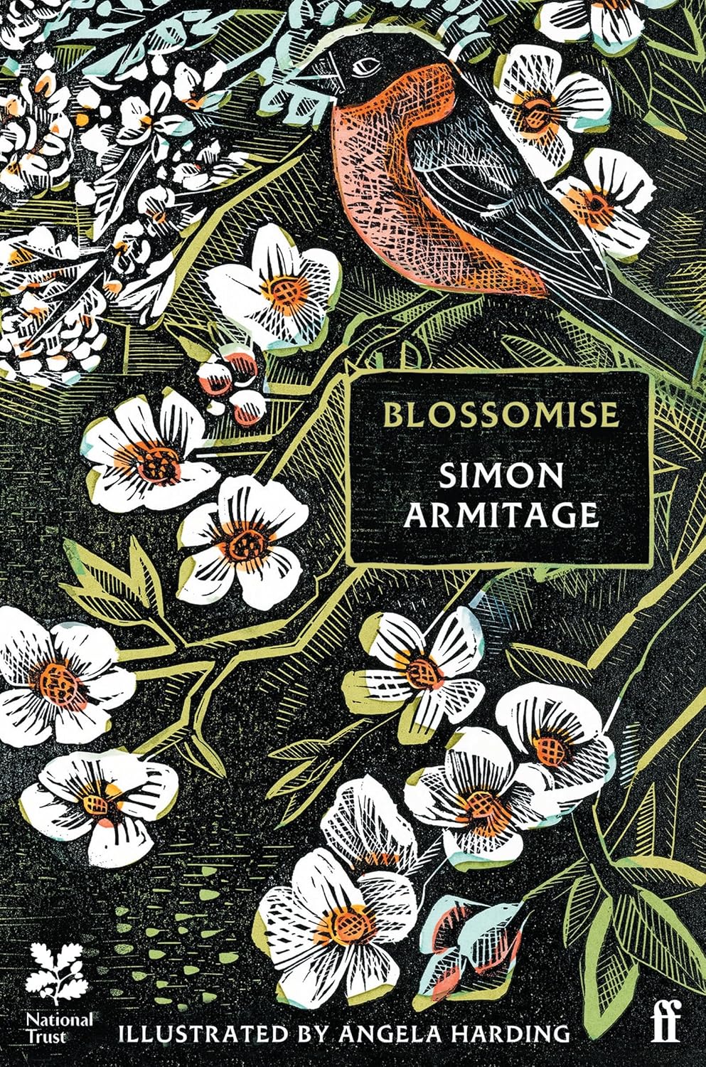
Blossomise is a collaboration between England’s poet Laureate and a talented printmaker, offering 21 beautiful poems to celebrate the spring and its blossom.
The book also has a serious note, looking at the demise of orchards which has led to less blossoming trees, so important for our planet, birds and wildlife. And our apples and pears!
Poetry is in debt to the environment, having had its money’s worth as a byword for beauty or a pretty backdrop. And poetry must speak up for nature, when it cannot speak for itself.
Watch Simon’s episode of the wonderful BBC series Winter Walks, in Yorkshire.
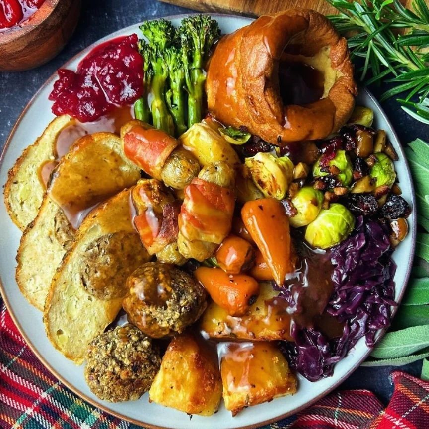
How to Make (vegan) Yorkshire Puddings

Yorkshire puddings are up there with one of England’s favourite foods. There are not many people who would not eat a plate of Yorkshire puddings on their own, not just with a veggie roast dinner! They are not the quickest recipe to make, but pretty simple once you get the hang of it. And who says you can’t enjoy Yorkshire puddings on any day of the week, not just Sunday!
These 5-ingredient vegan Yorkshire Puddings (Gaz Oakley) are the ultimate standby recipe, for when you fancy a snack or delicious side with your veggie Sunday roast. All you need is soy milk, self-raising flour, sea salt and baking powder, plus a little vegetable oil for greasing.
Preheat your oven, then add a little oil to each Yorkshire pudding tin, then pour the batter in heated oil and cook for 15 minutes.
Read our post on zero waste baking tools.
Avoid Yorkshire puddings for young children and people with swallowing difficulties (keep fresh dough away from children and pets). Don’t give leftovers to pets, garden birds or wildfowl, due to salt and fat (which can smear on feathers, affecting waterproofing and insulation).
It’s good to make vegan Yorkshire puddings, as these are from factory-farmed eggs and other animal ingredients. And most versions on sale are made with factory-farmed ingredients, and packed in plastic (there are a few plant-based alternatives listed below).
But let’s learn to make one of England’s most traditional foods, updated for health and compassion. You won’t regret it! Vegan Yorkshire puddings are cholesterol-free, so much healthier. Serve with vegan gravy.
Tips for Perfect Vegan Yorkshire Puddings
- Your oven must be very hot, to create enough steam to puff the batter, and crisp the outside. Avoid opening the oven door while baking, as this can cause the puddings to sink.
- The oil in each mould must be smoking hot, before you add the batter.
- Resting the batter for at least 20 minutes before baking, helps to hydrate the flour, and make your puddings puffy!
- Cool Yorkshire puddings on a wire rack, if not serving immediately. This will help to avoid them going soggy.
Homemade (vegan) Toad-in-The-Hole

This is also a traditional dish, ideal for a main meal or a snack. This toad-in-the-hole recipe (The Veg Space) uses ready-made vegan sausages in the batter, along with sliced onions. Once baked, serve with steamed greens and vegan gravy.
Where to Buy Good Vegan Yorkshire Puddings
Mabel’s offer a fine line of vegan Yorkshire puddings, all free of palm oil. You can order in bulk and freeze what you don’t need, and this company also can offer wholesale to shops. The range includes giant Yorkshire puddings and vegan toad-in-the-hole.
Recycle packaging at supermarket bag bins, if your kerbside doesn’t recycle.

Ella’s Instant Yorkshire Pudding Mix hails from Yorkshire and is sold in a brown paper bag. Also in a gluten-free version, and available in several flavours including garlic, chive and cheese, or a combination. Just follow the instructions, adding oat milk, soya milk and a little oil.
These mixes are made in a vegan kitchen, with 20p from each sale going to animal rescue charity. Again these are available wholesale to shops and restaurants.